Free Software for Orienteering and Open Orienteering Mapper
reviewed by Dick Keighley
One of the regular jobs encountered by the more technically inclined members of orienteering clubs is grappling with the software used for mapping, planning and administering events.
At Wimborne we use Autodownload for running competitions using SI and Condes for course planning. Both are commercial programs for which the club pays a licence fee. Autodownload costs us an annual fee whilst Condes cost us a once only payment for a licence.In each case, the licence is for the club, which means once a club has bought it, any member of the club can use the software on their computers.
For mapping, which is a more specialised art, the default software is the very expensive OCAD, now in version 11, although many clubs, like WIM, still use earlier versions. Unfortunately OCAD is sold with a single user licence, which means that (unless you use the free but antiquated OCAD 6 version, which has a lot of functionality missing on it and probably doesn't work properly on Windows 7 & 8) the software licence will only allow it to be used on one computer at a time.
However there are now free alternative programs emerging from amongst the FOSS (Free Open Source Software) community. Open Source software, which by definition is free to download and use, has always been stigmatised by the suspicion that Free = Poor quality. That may occasionally have been the case in the earlier days of computing but now the movement has matured and the best free software is of high quality and just as good as, and sometimes better than, the paid for software which it can replace. The classic example here is probably the Libre Office suite of office programs which can replace Microsoft Office.
Emerging now is free software for orienteering which can replace the expensive software we have used up to now. Many clubs now use the excellent American program Purple Pen rather than Condes for planning and course-setting. Purple Pen is perfectly adequate for most events, although it doesn't yet offer full support for the more complex relays, or MTBO and TrailO courses.
In Ireland, they use the Oŕ program for administering their SI events. Oŕ has most of the functionality of Autodownload and will allow its Irish users to connect to their archive of SI card owners, or post courses onto Routegadget. Indeed we've happily used it for smaller events before we upgraded the club laptops to Autodownload, which has been specifically written for orienteering in the UK, unlike the slightly unwieldy and complex OE2003 software we used to use when we first started using SI for events.
For drawing maps, there is now the Open Orienteering Map website which will produce orienteering style maps from the data in the Open Streetmap and which many clubs use to make street maps for urban Night events and the similarly names Open Orienteering Mapper (OOM), which although still in development is already becoming a suitable replacement for OCAD.
Now up to version 0.6, OOM has been written by a group of programmers at Garching University, near Munich in Germany. Whilst OOM has its own file format, it will open any OCAD file up to the latest OCAD 11. It will also save maps drawn in OOM into OCAD 8 format: licensing and copyright requirements don't it allow to save in higher versions (but OCAD versions 9-11 will also open OCAD 8 files so there is no problem swapping between the various programs.)
There are now versions of the software for Windows, Apple Mac, Linux computers and even an Android app.
Last year, I was asked to map the new primary school in my village, and I also had to map Sturminster Newton for a Summer League event. I'm not a particularly keen mapper and my arthritis won't allow me to stand or walk for more than a couple of hours surveying at a time but I was able to produce both maps from an OS base map using OOM version 0.5 software rather than OCAD, with the added assistance of Google Earth for aerial photos and Google Streetview which allowed me to 'walk' the streets of Sturminster looking for map detail (trees, street furniture etc.) from the comfort of the chair at my computer desk.
In many ways I found OOM easier to use than OCAD and the results looked more or less identical at the end of the day. The only problem I ran into, other than losing almost a quarter of the map when a thunderstorm crashed my computer and corrupted the map file, was producing the map legend.
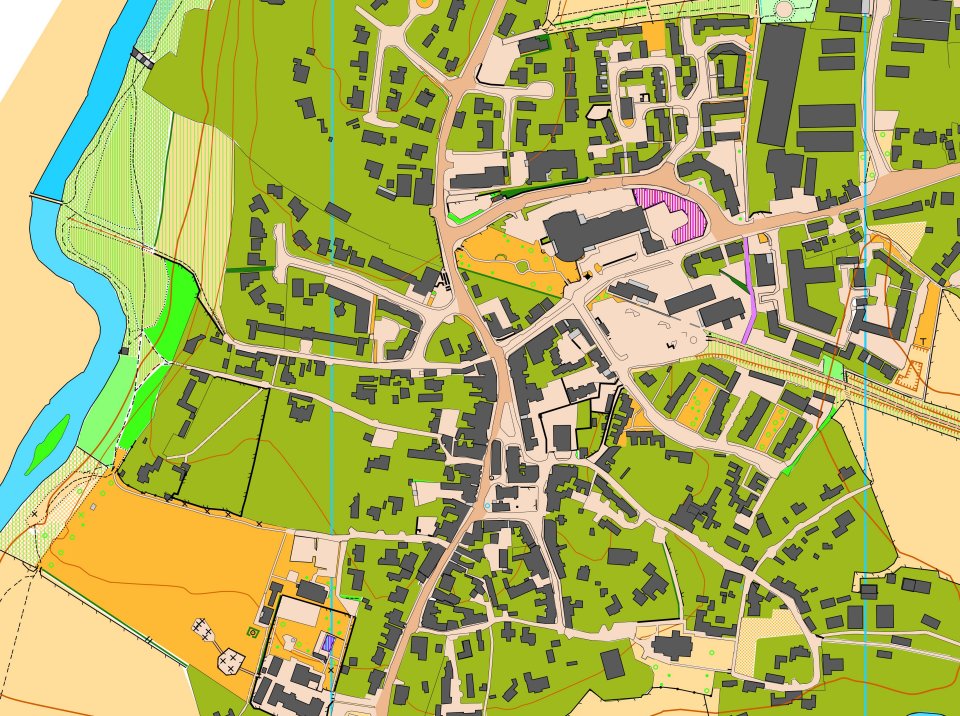
Sturminster Newton Town centre drawn in OOM – extract from 2013 map of Sturminster
In the end I drew the entire map in OOM, then saved the final map into OCAD and then did the title and legend of the map using OCAD, because I was in a hurry to get the map finished for the event and it was quicker to copy and paste the map legend from a previous OCAD map!
Recently OOM has moved on to version 0.6 which contains lots of improvements. Whilst the main program still doesn't automatically interface with GPS receivers, unlike the latest versions of OCAD, which are aimed at professional mappers, its getting closer.
The Android app now allows users to take their map file out into the field and use a smart-phone’s built-in GPS receiver to accurately fix the positions of features onto the map. Whilst I was writing this article I discovered the blog of an Australian mapper who explains
(http://greg.wilsonconnect.com/page2/) in great detail how to use free software and free map data to produce O maps. For the geeks amongst us, its fascinating reading and maybe the way forward.
Dick Keighley